Tonight we can expect to see temperatures drop into the single digits at 9°F with wind chill values as low as -5°F. With winds coming from the SW at 5-10 mph, it will feel much colder than our low at times, so make sure you dress in layers and stay warm!
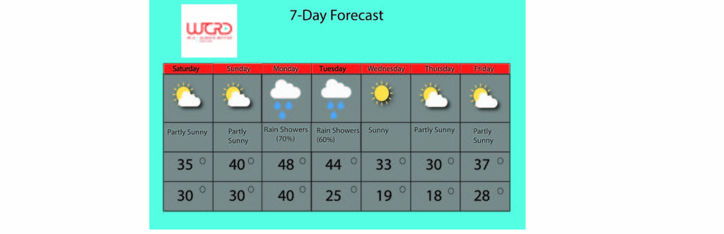
As for this weekend, we are expecting a high pressure system to make its way into the area, bringing with it sunshine and warmer temperatures.
On Saturday, it will be partly sunny with a high temperature of 36°F. There is less than a 10% chance for precipitation, although we will be seeing some pretty gusty winds. Winds will be coming from the south at 15-20 mph with gusts as high as 30 mph. The low temperature will be 30°F.
On Sunday, it will also be partly sunny with a high temperature of 40°F. Winds will calm, and with a less than a 10% chance of rain, Sunday looks like it will be a beautiful day!
As the high pressure system makes its way out, the start of the work week brings chances for precipitation and even warmer temperatures. On Monday, the high temperature will be 48°F with a 70% chance of wintry mix in the morning tapering off into rain for the afternoon. Tuesday will be very similar with a high temperature of 44°F and a 60% chance of rain throughout the day. On Wednesday, a cold front will make its way into our area. The high temperature will be 33°F and it will be sunny.

–WCRD Weather Forecaster Maddi Johnson
![]()