
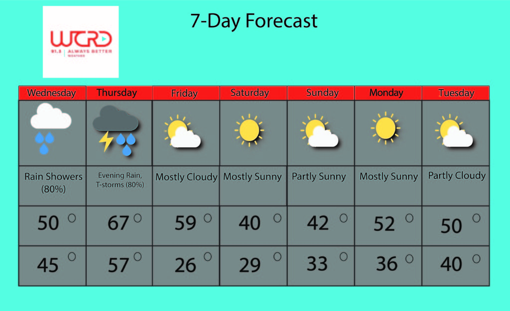
Tonight: High pressure is moving through Indiana right now, bringing partly sunny skies and temperatures in the 40s. Tonight, we’ll drop to a low of 36, with winds coming from the ESE at 5-10 mph. Make sure to keep a jacket on you tonight.
Tomorrow: Rain will be the big story tomorrow, as we expect a rain system to move in and dump at least 0.5 to 1 inches of rain in one hour. Winds might be gusty, with gusts above 20 mph possible. Make sure to drive carefully as you head home tomorrow evening.
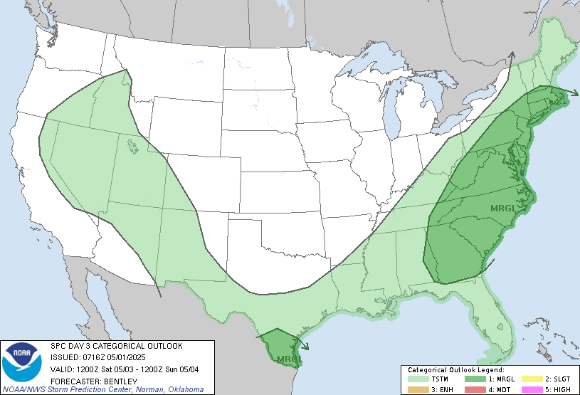
Thursday: The SPC has placed most of Indiana, including Delaware County, is under a marginal risk for severe weather, i.e. while unlikely, we could see some dangerous thunderstorms. This comes as a low-pressure system is expected to move into Indiana Thursday evening. Warm temperatures in the mid- to upper-60s might provide enough energy to create lots of rain showers and even a few thunderstorms. These thunderstorms, if they do occur, could bring heavy gusts and rain, which could make driving risky and cause loose objects to fly around. Even if thunderstorms don’t form, we do expect an inch of rain or more. Make sure to stay safe on Thursday, and we’ll be keeping an eye on this potential system.
7-Day: After the rain moves out Friday morning, expect a blast of cold air as a cold front moves from the northwest and brings cool air from the north into Indiana. Temperatures will drop into the upper-20s, so definitely keep a jacket near you for Friday night.
Over the weekend, highs will be in the low-40s, and lows will be in the upper-20s, so keep a heavy jacket near you for the weekend. But at least we expect partly sunny skies, so nice weather will be around.
After Sunday, expect temperatures to jump back into the upper-40s and low-50s, with partly sunny skies for both Monday and Tuesday.
Severe Weather Preparedness Week Topic 2: Warnings
Whenever severe weather strikes, weather forecasters often have to make sure that the public is aware of any dangerous conditions that could arise.
Therefore they issue watches (where they advise to look out for conditions that could spawn severe weather) and warnings (where severe storms have been observed or are about to form and thus require immediate action).
When severe storms are on the move, the NWS (National Weather Service) will issue warnings on NOAA weather radios and activate the Emergency Alert System if dangerous weather is imminent. Meanwhile, the media will broadcast any NWS warnings on TV and/or on social media, while showing more locations that could be hit as well as show live damage reports or spotter reports.
When any disaster hits, local responders will activate warning sirens and go out to any damage areas. The Indiana Department of Homeland Security will activate operations centers and work with local officials, while the American Red Cross will deploy to these operations centers or in damaged areas.
When severe weather strikes your home, the best response is to get your family (pets included) into a storm-resistant location, like a basement. Thereafter, continue monitoring for sources of emergency information.
For more information about Severe Weather Preparedness Week, check this out: https://www.weather.gov/ind/SevereWxWeek
-Weather Forecaster Joseph Williams

![]()