Tonight: The SPC still has us under a slight risk for severe weather. The warm front that is bringing us highs in the mid-70s is also setting the stage for severe thunderstorms to form and move through the area. As a cold front moves through during the overnight hours, thunderstorms could roll thorugh the area during the overnight hours, after 11 pm. Some of them could bring damaging winds, heavy rain, and even hail, meaning that these thunderstorms will cause problems. Make sure to stay home and have a family safety plan in case severe weather happens in your neighborhood. We’ll keep you updated on this severe weather threat.

Tonight: The SPC still has us under a slight risk for severe weather. The warm front that is bringing us highs in the mid-70s is also setting the stage for severe thunderstorms to form and move through the area. As a cold front moves through during the overnight hours, thunderstorms could roll thorugh the area during the overnight hours, after 11 pm. Some of them could bring damaging winds, heavy rain, and even hail, meaning that these thunderstorms will cause problems. Make sure to stay home and have a family safety plan in case severe weather happens in your neighborhood. We’ll keep you updated on this severe weather threat.
Tomorrow: Another warm day is expected tomorrow, with a high of 70 expected for tomorrow. Skies will be mostly cloudy, but it will still be a nice day to go outside. However, tomorrow night, another low-pressure system will bring rain chances during the evening hours, after 9 pm. Heavy rain and gusty winds are expected, so make sure to stay safe for tomorrow night. Thereafter, as the cold front passes through, temperatures will plummet into the mid-40s, so keep a blanket with you for tomorrow night.

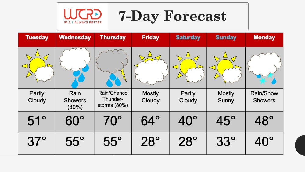
7-Day: After Wednesday, the rest of the week should involve cooler-than-normal temperatures for this time of year, as cold air moves from the north into Indiana. Expect temperatures to fluctuate between the mid-40s to low-50s, with Saturday and Sunday seeing the warmest temperatures. Saturday and Sunday could see some rain moving in, so keep an umbrella with you during the weekend. Otherwise, it will be a nice week out.
-Weather Forecaster Joseph Williams
Tonight: The SPC still has us under a slight risk for severe weather. The warm front that is bringing us highs in the mid-70s is also setting the stage for severe thunderstorms to form and move through the area. As a cold front moves through during the overnight hours, thunderstorms could roll thorugh the area during the overnight hours, after 11 pm. Some of them could bring damaging winds, heavy rain, and even hail, meaning that these thunderstorms will cause problems. Make sure to stay home and have a family safety plan in case severe weather happens in your neighborhood. We’ll keep you updated on this severe weather threat.
Tomorrow: Another warm day is expected tomorrow, with a high of 70 expected for tomorrow. Skies will be mostly cloudy, but it will still be a nice day to go outside. However, tomorrow night, another low-pressure system will bring rain chances during the evening hours, after 9 pm. Heavy rain and gusty winds are expected, so make sure to stay safe for tomorrow night. Thereafter, as the cold front passes through, temperatures will plummet into the mid-40s, so keep a blanket with you for tomorrow night.
7-Day: After Wednesday, the rest of the week should involve cooler-than-normal temperatures for this time of year, as cold air moves from the north into Indiana. Expect temperatures to fluctuate between the mid-40s to low-50s, with Saturday and Sunday seeing the warmest temperatures. Saturday and Sunday could see some rain moving in, so keep an umbrella with you during the weekend. Otherwise, it will be a nice week out.
![]()